A River under Siege
China’s planned $137 billion Medog dam on the Yarlung Tsangpo poses ecological, seismic, and strategic risks for India and particularly the northeastern states, threatening water security, river ecology, and geopolitical stability.
- Apr 01, 2025,
- Updated Apr 01, 2025, 12:08 PM IST
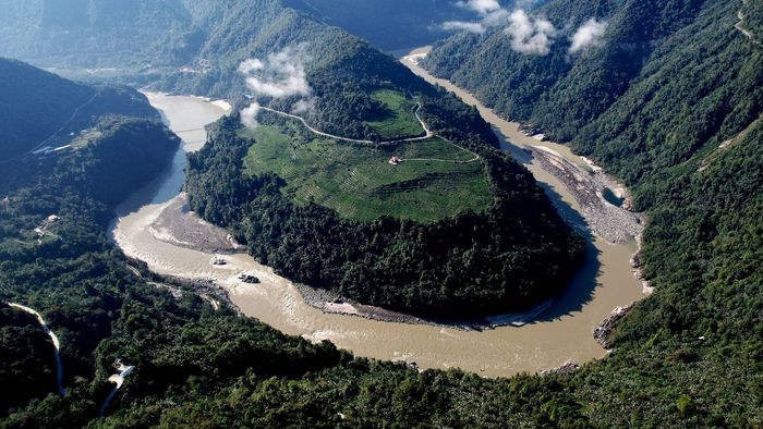
Picture this: Originating from the icy grip of the Angsi Glacier, near the northern slopes of the Himalayas, close to Lake Manasarovar in western Tibet, the Yarlung Tsangpo—known as Siang in Arunachal Pradesh and Brahmaputra in Assam—begins its epic journey. It flows eastward across the Tibetan Plateau, a seemingly calm giant, until it reaches the easternmost edge of the Himalayas. And then, it encounters an obstacle—Namcha Barwa, a towering 7,782-meter peak. But this river does not stop. In one of nature’s most breathtaking feats, it executes a dramatic U-turn around the mountain—the Great Bend, one of the sharpest and most spectacular river bends on Earth.
What follows is pure fury. The river plunges into the depths of the Yarlung Tsangpo Grand Canyon, a monstrous 500-km-long chasm with depths exceeding 5,000 meters—nearly five times the height of the Burj Khalifa. It is one of the deepest and most treacherous canyons in the world, where the river transforms into a roaring beast, its waters churning with an unstoppable force.
And this is where China wants to step in. The steep gradient at the Great Bend holds unparalleled hydroelectric potential—an energy goldmine that Beijing is determined to exploit. The plan? A colossal hydropower project embedded deep into the unforgiving terrain of Medog County, Tibet—one of the last unexplored and most geologically unstable regions on Earth.
It is a project of staggering proportions, a testament to human ambition and engineering audacity. With an estimated cost of $137 billion, this mega-dam is poised to become the most powerful hydropower facility ever attempted, generating a jaw-dropping 60 gigawatts of electricity annually—three times the output of China’s own Three Gorges Dam, the current world record-holder. The scale is mind-boggling. To divert nearly half of the river’s flow, Chinese engineers plan to drill tunnels up to 12.5 miles long through the Namcha Barwa mountain, rerouting 2,000 cubic meters of water per second—enough to fill three Olympic-sized swimming pools every second.
But while China frames it as a step toward carbon neutrality by 2060, for India and Bangladesh, this project sounds nothing short of a looming catastrophe. The site of the dam lies just over 30 km from India’s Arunachal Pradesh, bringing the project perilously close to the border and raising security concerns in New Delhi. Prophets of catastrophe have sketched apocalyptic visions. If this dam were to fail—whether due to engineering flaws, an earthquake, or deliberate sabotage—the consequences would be unthinkable. A towering surge of water could sweep through Arunachal Pradesh and Assam, obliterating entire towns within minutes. Nayan Sharma, former professor at IIT Roorkee specialising in river engineering, dams, and irrigation science, warns of dire repercussions. “The Great Bend may provide an optimal location for energy generation, but it also amplifies the risk of disaster in the event of a dam failure,” he cautions. “With a storage capacity of up to 60 billion cubic meters (BCM) of water, a breach could unleash devastation on an unimaginable scale.”
Why India and Bangladesh are worried
Downstream nations fear that China’s dams could disrupt the Brahmaputra’s delicate hydrological balance. Spanning 3,350 kilometers, the river’s basin covers four countries—China (50.5%), India (33.6%), Bangladesh (8.1%), and Bhutan (7.8%). More than just a river, the Brahmaputra is a lifeline for millions, sustaining agriculture, drinking water, and energy needs.
India’s primary concern is China’s ability to control the Brahmaputra’s water flow. If Beijing releases excess water during monsoons, it could trigger devastating floods in India’s northeastern states, particularly Assam and Arunachal Pradesh, where nearly 40 percent of the land is already flood-prone. The consequences—mass displacement, infrastructure collapse, and economic devastation—would be severe. Conversely, restricting water flow during dry months could be equally catastrophic, affecting agriculture, hydropower generation, and drinking water supplies. Given that the Brahmaputra accounts for nearly 30 percent of India’s freshwater resources, any disruption poses a strategic threat.
“The proposed hydropower project, given its anticipated scale, has the potential to alter the flow dynamics of the Yarlung Tsangpo-Brahmaputra, affecting water availability by influencing both groundwater and surface water levels,” warns Genevieve Donnellon-May, a researcher at the Oxford Global Society.
For Assam, the implications for agriculture are particularly alarming. The river’s nutrient-rich sediments sustain rice, tea, and jute cultivation. Any disruption—whether excessive flooding or drought—could lower crop yields, threaten food security, and financially cripple thousands of farmers. Additionally, the Brahmaputra’s natural sediment deposits help maintain soil fertility. If upstream damming reduces sediment flow, it could accelerate riverbank erosion, degrade agricultural productivity, and leave lasting ecological scars.
For Bangladesh, the stakes are even higher. As the last riparian nation before the Brahmaputra empties into the Bay of Bengal, its water security is deeply dependent on upstream activities. Any disruption in the river’s flow could devastate agriculture, fisheries, and drinking water supplies. Bangladesh’s floodplains rely on periodic inundation to replenish soil nutrients vital for rice cultivation. If this natural cycle is altered—either through extreme flooding or prolonged drought—millions of farmers could suffer. Additionally, reduced water levels could increase salinity intrusion in coastal areas, jeopardising food production and accelerating environmental decline.
“The Brahmaputra not only supplies water but also carries sediment to Bangladesh and India. Any alteration in sediment levels downstream could lead to riverbank erosion in both India and Bangladesh. Additionally, over 70 percent of the freshwater flow in Bangladesh during the dry season originates from the Brahmaputra. Any disruption in this flow raises concerns about increased salinity intrusion in Bangladesh’s coastal regions.” Says Malik Fida A Khan, Executive Director at Centre for Environmental and Geographic Information Services (CEGIS)
India’s concerns over China’s hydropower ambitions are well-founded. In 2000, Arunachal Pradesh’s Pasighat experienced severe flooding due to a dam collapse on Tibet’s Yigong River. In 2012, the Siang River mysteriously ran dry, with then-Chief Minister advisor Tako Dabi pointing fingers at China’s dams. In 2016, China blocked the Xiabuqu River near India’s border for the Lalho hydropower project, raising further suspicions. A year later, the Siang’s waters turned black—India accused China, while Beijing dismissed the claims.
The absence of transparent data-sharing deepens mistrust, making it nearly impossible for downstream nations to verify or challenge China’s actions. Satellite images later revealed that earthquakes on the Tibetan Plateau had triggered landslides, sending sediment downstream.
“Storing water in a region with extensive mineral extraction—Tibet, home to over 100 exploited minerals—leads to contamination as mining runoff mixes with the water, forming black soot. Arunachal Pradesh has already seen instances of blackened water, leaving authorities scrambling for solutions,” says Srikanth Kondapalli, Professor of Chinese Studies at Jawaharlal Nehru University.
Open-source data from the Tibetan Autonomous Region (TAR) indicates irregular river flow patterns in 2024, deviating from trends observed over the past 25 years. These fluctuations suggest that the river system may already be under stress due to natural or human-induced factors. The simultaneous construction of multiple smaller dams alongside the planned mega-dam only adds to the uncertainty, making it difficult to predict the full extent of downstream consequences.
What raises even deeper concerns is China’s plan to divert the Yarlung Tsangpo—the upper stretch of the Brahmaputra—to its arid Xinjiang province. This proposal is linked to the South-North Water Transfer Project, a scheme first envisioned by Mao Zedong in the 1950s and later revived in Li Ling’s 2005 book, Tibet’s Water Will Save China. The Yarlung Tsangpo has long been viewed as a “river gone rogue” in Chinese history due to its unusual west-to-east flow before dramatically turning south into India. Some argue that China’s large-scale dam projects are an attempt to “correct” this natural course.
Launched in 2002, the South-North Water Diversion Project is China’s most ambitious water transfer initiative, designed to divert up to 45 billion cubic meters of water annually from southern rivers to its arid north. China’s grand water diversion plan envisions constructing a canal intersecting six major rivers—the Brahmaputra, Nu, Lancang, Jinsha, Yalong, and Dadu. “The real worrisome situation,” says Professor BR Deepak of the Centre for Chinese & Southeast Asian Studies at JNU, “is that China plans to bridge the distance between the Brahmaputra and the Yellow River with a 240-kilometer-long tunnel, diverting around 200 billion cubic meters of water—equivalent to four Yellow Rivers.” Gopal Dhawan, Founder and Chairman of the Dr. Dhawan Academy of Geologists and former CMD of MECL and NHPC, warns that if China stores and redirects water through an inter-basin transfer scheme, “any projects we develop will face water shortages and be adversely affected.”
However, not all experts share this concern. “Unlike the popular perception of China drying out India’s northeast, that will certainly not be the case,” says Sayanangshu Modak, a doctoral researcher at the University of Arizona’s School of Geography, Development, and Environment. “For all we know, the Medog project will be a run-of-the-river project based on available information. There is no way the water from the Yarlung Tsangpo would be diverted out of the Brahmaputra system.”
Despite reassurances, uncertainty about China’s long-term intentions persists. “So far, three dams are being developed upstream—one completed and two under construction. None appear to be diverting water, as they are all run-of-the-river projects. The Medog dam also appears to be a hydroelectric project rather than a water storage and diversion initiative. But given China’s track record of undertaking large-scale infrastructure projects, such a possibility cannot be ruled out,” says AK Bajaj, former chairman of the Central Water Commission.
New Delhi’s response has been unequivocal. “We have consistently expressed our concerns to the Chinese side over mega projects on rivers in their territory,” Indian Foreign Ministry spokesperson Randhir Jaiswal stated. He emphasised that India, as a lower riparian state with established user rights, has urged China to ensure that downstream interests are not harmed. “We will continue to monitor and take necessary measures to protect our interests,” he added.
China’s water hegemony
The Tibetan Plateau serves as the source of 10 major river systems that sustain more than a dozen countries across Asia. Among these rivers, two hold immense geopolitical significance: the Mekong, which flows through Southeast Asia, and the Brahmaputra, which traverses India and Bangladesh. Beijing’s dam-building spree on these waterways has sparked widespread concerns over its ambitions for hydro-hegemony, particularly given its refusal to enter into formal water-sharing agreements with downstream nations. In 2020, the Lowy Institute, an Australian think tank, highlighted how Beijing’s unchecked control over Tibetan rivers effectively gives it a “chokehold” on India’s economy. “As the upper riparian state, China holds a dominant position over Asia’s major transnational rivers, most of which originate in Tibet. This status effectively makes China the region’s hydro-hegemon, giving Beijing strategic leverage over downstream nations,” says Donnellon-May.
China’s handling of the Mekong River offers a cautionary tale for India and Bangladesh. Over the past two decades, Beijing has built 12 large dams along the Mekong’s upper reaches, profoundly altering water flow and exacerbating ecological distress in downstream nations. In 2019, despite experiencing above-average rainfall, China’s upstream dams withheld record amounts of water, causing a severe drought in Thailand, Cambodia, and Vietnam. The following year, in 2021, Beijing abruptly cut Mekong water flow by 50 per cent for three weeks, citing power-line maintenance—without prior warning to affected nations. Millions of people who rely on the river for agriculture, fisheries, and drinking water were left scrambling to cope with the consequences.
These instances of unilateral water management reinforce fears that Beijing could deploy similar tactics on the Brahmaputra, particularly during periods of heightened geopolitical tension. In 2017, following a military standoff between Indian and Chinese troops at Doklam—a strategically sensitive region near Bhutan—China abruptly stopped sharing crucial hydrological data with India. That same year, devastating floods struck the northeastern Indian state of Assam, killing more than 70 people and displacing over 400,000.
The Medog dam is not an isolated initiative but part of a long-term blueprint. Modak points out that this construction of this dam was inevitable, and in fact, this stretch of the Yarlung had been marked for hydropower development as early as 2003 according to hydropower project inventory map by Hydrochina, Beijing. “This stretch of the river offers one of the world’s most favourable hydraulic gradients on the planet for hydropower development. Just consider the fact about the underutilisation of the Yarlung Zangbo basin, where only 0.3 per cent of the total energy potential in the Yarlung Zangbo basin has been harnessed, compared to the other river basins of China like 24.6 per cent for the Yangtze, 34.2 per cent for the Yellow, and 58 per cent for the Pearl River basins,” says Modak.
Since the early 2010s, China has steadily expanded its hydropower footprint along the Brahmaputra’s upper reaches. The Zangmu hydropower station, completed in 2015, marked the beginning of this expansion, followed by planned projects at Dagu, Jiacha, and Jiexu. Satellite imagery has already identified nearly 20 dams along the river, underscoring the scale of China’s long-term water agenda.
For India, the timing of China’s announcement decision to approve the Medog dam has raised suspicion about Beijing’s intent. The approval of the project coincided with the resumption of India-China discussions after a prolonged freeze, following two major flashpoints—the Doklam standoff in 2017 and the Galwan Valley clashes in 2020. Many analysts view China’s decision to publicise the dam at this juncture as a deliberate manoeuvre to gain leverage in ongoing diplomatic and territorial negotiations. It signals Beijing’s intent to assert control over the Brahmaputra’s waters and underscores its readiness to use water security as a geopolitical bargaining chip. More than an actual commitment to construction, China’s grand announcement appears to be aimed at unsettling India. By linking border disputes to transboundary rivers, Beijing likely hopes to pressure New Delhi into making concessions on territorial issues.
Is India over reacting?
While concerns over the Medog dam’s potential impact on India's water security have sparked intense debate, some experts argue that these fears may be overstated. China maintains that its hydropower projects on the Yarlung Tsangpo, including Medog, are run-of-the-river systems, meaning they do not involve large-scale water storage or significant diversion. (Run-of-the-river hydroelectric systems generate electricity using the natural flow of water without major reservoirs.) While some caution that such projects could reduce water flow during dry seasons, experts suggest the overall impact is unlikely to be catastrophic. “The proposed hydropower project is not as alarming as it might seem,” says Ruth Gamble, Deputy Director (Research) at La Trobe Asia, La Trobe University, Australia. A historian specializing in the environmental, cultural, and climate history of Tibet, the Himalaya, and Asia, Gamble is currently working on her third book—a history of the Yarlung Tsangpo (Brahmaputra) River.
“While the Medog project is a significant hydropower initiative, it does not require the construction of a massive dam. Instead, it harnesses the river’s energy through its steep descent rather than relying on a large reservoir. Although a small reservoir will be built for water storage, its scale will be minimal,” she explains.
However, this perspective is contested. Mirza Zulfiqur Rahman, Visiting Associate Fellow at the Institute of Chinese Studies, disagrees, arguing that this view takes a narrow approach to river systems. “A river system isn’t just about surface water—it includes groundwater and atmospheric water patterns, or what we call the ‘sky river.’ Monsoon patterns, largely shaped by wind flows, play a crucial role in river ecology. Any disruption to surface water can trigger cascading effects on groundwater and atmospheric water cycles, potentially altering monsoon patterns and leading to deficient rainfall in India,” says Rahman.
Even Gamble acknowledges the risks associated with building a run-of-the-river dam in such an ecologically sensitive region. “The Medog project involves tunnelling through highly unstable terrain, and even a small reservoir will be situated in a precarious zone. Any form of land movement—landslides, avalanches, or outburst floods—could unleash immense force. While the river’s powerful flow is ideal for hydropower generation, it also presents serious risks for dam construction,” she warns. Rahman adds, “A project of this scale will require massive infrastructure investments and significant interventions in the river system, which will inevitably have adverse effects on the fragile ecology of the region.”
Moreover, the precise contribution of the Yarlung Tsangpo to the Brahmaputra remains disputed due to inconsistencies in available data. Peer-reviewed studies suggest that, both in lean and peak flow periods, the total annual outflow of the Yarlung Tsangpo from China is significantly lower than that of the Brahmaputra. This indicates that India, as the primary downstream country, retains substantial control over its water resources.
Modak argues that the Yarlung Tsangpo’s catchment area does not generate enough water to significantly impact India’s supply. “Much of the Brahmaputra’s flow, after the confluence of the Siang, Dibang, and Lohit rivers, is contributed by precipitation south of the Himalayan crestline and the South Asian Summer Monsoon,” he explains.
Professor Deepak highlights this perspective: “According to China, the Brahmaputra spans approximately 1,000 km, with 725 km in India and 274 km in Bangladesh. If we compare the annual mean runoff of tributaries within India—such as the Lohit, Subansiri, Kameng, and Manas—it amounts to 618 billion cubic meters, whereas the Yarlung Tsangpo contributes only 165 billion cubic meters upstream in Tibet. From this perspective, the fears appear overstated. However, a mega dam upstream still comes with considerable risks and challenges”.
However, not all experts agree with this assessment. Rahman argues that the Yarlung Tsangpo remains the Brahmaputra's principal source. “While monsoon rains within India contribute significantly, the river’s perennial flow is sustained by the glacial headwaters of the Yarlung Tsangpo. As the main branch of the Brahmaputra, it provides the maximum volume of water to the system as it enters India,” he notes.
Bajaj also underscores the strategic risks associated with China's control over the river’s flow: “The Brahmaputra generates around 72 billion cubic meters of water before reaching the site where China is constructing the dam. However, by the time it flows through Bangladesh, its total water volume reaches 569 billion cubic meters. This means that 490 billion cubic meters are generated within India and Bangladesh, while only 72 billion originate in China. But the issue is not just the quantity of water but the control China gains. If they choose, they could withhold water for 12 to 15 days, temporarily cutting off India’s supply before releasing it at their discretion. This level of control presents a significant strategic challenge for India.”
Why this dam is dangerous
While debate continues over the extent of damage China’s proposed Medog Dam might inflict on India and Bangladesh, there is broad consensus among scientists, environmentalists, and geologists that its construction poses severe and irreversible ecological risks to the fragile Himalayan region. The Tibetan Plateau emerged millions of years ago when the Indian and Eurasian tectonic plates collided. Even today, the Indian plate continues its slow advance toward the Eurasian plate, causing frequent earthquakes in the Himalayas. The region accounted for 15 percent of the world’s great earthquakes (magnitude 8.0 and above) in the 20th century. In 2024 alone, Tibet recorded over 100 earthquakes above magnitude 3.0. A 6.8-magnitude quake near Tingri on January 7 caused widespread destruction.
It is known that dams can also create the conditions for tremors and earthquakes, a process known as ‘reservoir-induced seismicity’, in which the weight of water held back by a dam triggers tremors.
Studies indicate how the reservoirs, with their water load, may alter the strain field, thereby increasing the frequency of earthquakes. “The sheer weight of a vast reservoir could induce small earthquakes by exerting pressure on the Earth’s crust. In a region already prone to intense seismic activity, the consequences of such stress remain highly uncertain,” says Robert Wasson, Adjunct Professor, College of Science and Engineering, James Cook University, Australia and Emeritus Professor, Fenner School of Environment and Society Australian National University and Shukla Acharjee, Assistant Professor, Centre for Studies in Geography, Dibrugarh University
China’s chosen site for the Medog Dam—the Great Bend—is a seismic hotspot prone to landslides. The site itself carries a legacy of destruction: the 1950 Medog Earthquake—also known as the Assam-Tibet Earthquake—one of the most powerful in modern history, reshaped river courses and left downstream regions in Assam and Bangladesh trapped in an endless cycle of catastrophic floods.
The Medog Dam’s sheer scale demands extensive deforestation, endangering the region’s fragile green cover. The Himalayan forests—critical carbon sinks and biodiversity hotspots—would be fragmented, pushing endangered species like the snow leopard, red panda, and takin closer to extinction. The loss of tree cover would also accelerate soil erosion, triggering frequent and severe landslides. Without stabilizing roots, heavy monsoonal rains could unleash catastrophic mudslides, raising the risk of dam failure. Given the Himalayas’ accelerating glacial melt, the dam could further destabilize the Brahmaputra Basin’s hydrology. “The Tsangpo Gorge is one of the most geologically dynamic—and possibly the most active—regions on Earth. It experiences extreme floods, with peak flows reaching up to a million cubic meters per second. A single such flood can erode as much of the gorge as 4,000 years’ worth of annual flow,” say Wasson and Acharjee.
As Modak says, a major concern for downstream India regarding the dam is the risk of dam failure during emergencies caused by unprecedented weather or seismic events. Exogenic processes, such as the steady influx of moisture and abnormal precipitation, have also triggered mass movements, including glacier collapses, avalanches, landslides, and Glacial Lake Outburst Floods (GLOFs). “For example, on March 22, 2021, a massive glacier collapsed in the Sedongpu River basin, on the left bank of the Grand Canyon of the Yarlung Tsangpo and blocked the river and caused water levels to rise by 10 meters,” he says.
Experts also warn that melting glaciers will create unstable lakes, causing downstream devastation. In 2017, an earthquake near the Great Bend triggered massive mountain slides, forming two precariously unstable lakes. Since 1980, over 600 flash floods have been recorded in the Yarlung-Brahmaputra basin. Additionally, the loss of glacial mass could trigger isostatic rebound, increasing seismic activity in the region. The UN’s IPCC has already raised concerns about the rapid degradation of Tibetan permafrost, which is warming three times faster than the global average. “The Yarlung Tsangpo-Brahmaputra is already experiencing stress from climate change. Rising temperatures and receding glaciers pose a threat to the river’s flow, which could have long-term consequences for water availability and potentially affect its quality as well,” says Donnellon-May.
The region’s volatile geomorphology makes dam stability a growing concern. Earthquakes, heavy siltation, and landslides will shorten the dams’ lifespan. After the January 7 earthquake, inspections of 14 hydropower dams in Tibet found structural cracks in five, forcing three to be emptied. “This region is the most sediment-rich and sediment-producing area on Earth. As a result, dams here degrade faster, increasing the risk for downstream populations,” says Gamble.
China’s defence
On its part, China insists the Medog project is a clean energy game-changer, not a geopolitical weapon. Wang Lei, chargé d’affaires at the Chinese Embassy in India, dismisses concerns about adverse impacts on India and Bangladesh, framing the project as a climate-friendly solution that will power 300 million people while curbing fossil fuel use. Backing this stance, Chinese foreign ministry spokesperson Guo Jiakun says the project underwent rigorous scientific evaluation and poses no risk to downstream ecosystems, geological stability or water rights. Instead, Beijing argues it will help mitigate floods and aid climate adaptation in India and Bangladesh.
Can we trust China
China’s assurances on the Medog Dam ring hollow, given its track record of secrecy, unilateralism, and broken commitments on transboundary rivers. Experts also argue that historical statistical data is no longer a reliable predictor, given the rapid ecological changes underway. Even if China has analyzed past hydrological flows and conducted extensive modeling, Modak asserts that climate change has introduced significant non-stationarity in hydroclimatic variables, making these models increasingly unreliable. “Our very own Himalayan catastrophes are a testament to this – take the case of the Chamoli disaster of 2021 in Uttarakhand, or the Chungthang dam collapse of 2023 in Sikkim,” says Modak.
India’s response
A decade ago, India embarked on a defensive hydropower strategy to counter China’s upstream dam-building spree on the Brahmaputra. Rooted in the international legal principle of “prior appropriation”—which grants water rights to the first user—India’s plan aims to preemptively secure control over the river’s flow.
“India’s dam-building efforts make sense from the standpoint of water security, renewable energy, and flood control,” says Deepak. Kugelman says that India can still challenge Beijing by constructing its own dams near the border, keeping China on edge. This would give New Delhi some leverage in potential water negotiations with Beijing. “To manage this risk, India should build a major dam on the Brahmaputra immediately after it enters Arunachal Pradesh,” adds Bajaj.
The Siang Upper Multipurpose Project (SUMP)—a massive hydropower dam in Arunachal Pradesh designed to counter China’s control over the river. With a planned 11,000-megawatt capacity and a 9.2 billion cubic metre reservoir, SUMP aims to regulate water flow, mitigate seasonal droughts, and act as a buffer against sudden surges from Chinese dams.
At an estimated Rs 1.5 lakh crore ($13.2 billion), SUMP will be India’s most powerful hydroelectric project. Feasibility surveys are underway in Parong, a remote hamlet in Arunachal Pradesh’s Siang district. The project would dwarf China’s Medog dam, whose 5.5 bcm storage capacity is significantly smaller than India’s planned 9.2 bcm—enough to neutralise a potential upstream “water bomb” release.
Yet, SUMP remains contentious. Since its proposal by NITI Aayog in 2017, resistance has grown. Over 30 villages, including Parong, Sitang, Riga, Geku, and Dite Dime, face submersion, threatening mass displacement. Experts warn that the risks extend beyond mere displacement. They caution that China might accelerate its own dam projects in response, leveraging its superior execution speed to further tilt the balance in its favour. This intensifying dam race could also alienate Bangladesh, a key downstream stakeholder in any future Brahmaputra basin management agreement. Moreover, constructing two massive dams in a seismically active and flood-prone region poses severe ecological risks, potentially endangering millions living downstream.
Others advocate for smaller, more sustainable alternatives. “A viable and environmentally responsible solution is pumped storage hydropower (PSH), a form of hydroelectric energy storage. It involves two reservoirs at different elevations, generating power as water flows downward through a turbine. During periods of low demand, energy is used to pump water back to the upper reservoir, effectively storing power for later use. Unlike traditional hydropower projects, PSH does not require massive reservoirs and instead relies on multiple smaller ones," explain Wasson and Acharjee.
Rather than engaging in an unsustainable dam-building spree, experts advocate India must strengthen its northeastern water management capabilities—enhancing independent river flow monitoring from China through advanced satellite technology, refining flood risk mapping, and upgrading telemetry stations.
Gamble highlights India’s lag in studying Himalayan ecology and river systems compared to China. “While India has raised objections to China's activities, its own research on this side of the border has been far less comprehensive. In fact, India has yet to fully examine the flow data China has provided on the Yarlung Tsangpo River. Instead of merely issuing threats over dam construction, India must invest in understanding the region’s realities and risks. With this knowledge, India can engage China in a constructive dialogue, presenting evidence on how downstream impacts will affect it,” says Gamble.
What’s the way forward
India and China share several major rivers, including the Brahmaputra, Sutlej, and Indus—vital to both nations, supplying drinking water, irrigation, and hydropower. However, water-sharing remains a contentious issue, exacerbated by political tensions. China’s control over the upper reaches of these rivers gives it a strategic advantage, allowing it to regulate flow, a leverage India finds concerning.
Compounding the issue is the absence of a formal water-sharing treaty. Instead, both countries operate under a patchwork of periodically renewed memorandums of understanding (MoUs). The 2002 MoU on Brahmaputra flood-season hydrological data was last renewed in 2018, while a similar agreement on the Sutlej dates back to 2004. Both expired in 2023, though China continues to share Sutlej data. Efforts to renew these agreements were discussed during a meeting on December 18 last year between India’s National Security Advisor Ajit Doval and Chinese Foreign Minister Wang Yi, where cross-border river data sharing was a key agenda point.
However, these MoUs lack legal enforceability and dispute-resolution mechanisms. While India and China engage through an Expert Level Mechanism (ELM) on transboundary water issues since 2006, it has failed to resolve key disputes. Experts argue that a legally binding framework is needed to ensure real-time data sharing.
Data transparency alone won’t resolve the geopolitical strains. A broader multilateral framework involving India, Bangladesh, and Bhutan is necessary to address environmental concerns and ensure transparency in dam operations. A 2022 Oxfam-backed report by Sajid Karim and Ashok Swain estimated that greater cooperation among the Ganges-Brahmaputra-Meghna nations could save the region $14.2 billion annually through improved flood management, agricultural efficiency, and disaster preparedness.
China’s grand Medog dam is more than a feat of engineering; it’s a geopolitical time bomb. While Beijing touts it as a green energy marvel, its sheer scale and location—on one of the most volatile river systems in the world—raise the spectre of environmental collapse, seismic catastrophe, and a strategic power shift in Asia’s water politics. India faces a stark choice: reactively brace for disruptions or proactively secure their water future through robust diplomacy, technological preparedness, and regional cooperation. In the Brahmaputra’s turbulent waters, survival will depend not on the might of dams but on the foresight of nations.
With inputs from India Today NE bureau
A shorter version of this story appears in the April 7, 2025 issue of India Today magazine.