Assam’s land is disappearing: State tops India’s erosion-affected regions
Assam leads India in land erosion, driven by the Brahmaputra River's changing course. Efforts to combat the crisis include embankments and afforestation
- Mar 26, 2025,
- Updated Mar 26, 2025, 4:14 PM IST
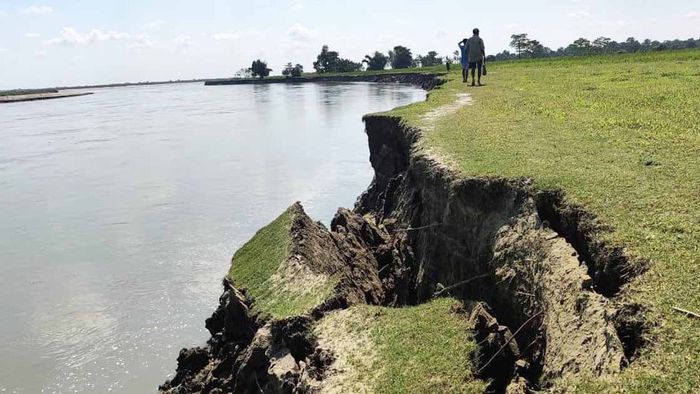
Assam is grappling with an escalating crisis as relentless riverbank erosion continues to consume vast stretches of land, altering the state’s geography and displacing thousands. The state now holds the unfortunate distinction of being India’s most erosion-affected region, with extensive land loss recorded over the decades.
Despite ongoing government interventions, erosion remains a formidable challenge, threatening livelihoods, critical infrastructure, and Assam’s natural landscape.
Extent of erosion in Assam
Riverbank erosion in Assam has emerged as a persistent environmental and socio-economic threat. The Brahmaputra and its tributaries have been steadily devouring land, erasing villages, and reshaping the state’s topography.
Official data from the Assam State Disaster Management Authority (ASDMA) indicates that approximately 386,476 hectares of land have been lost since 1954—nearly 7% of the state's total area. However, estimates from the Water Resources Department suggest an even more alarming figure, placing the total land loss at over 427,000 hectares since 1950, equivalent to 7.4% of Assam’s total landmass.
On average, the state loses 8,000 hectares of land annually to erosion, forcing thousands of families to abandon their homes and farmland. This steady land depletion has not only reduced Assam’s geographical footprint but has also intensified economic distress in rural communities.
Most vulnerable districts
Assam is home to nine of India’s 22 most erosion-affected districts, making it the most vulnerable state in the country. These districts, located along the Brahmaputra and its tributaries, have witnessed severe land degradation over the years, leading to mass displacement and economic turmoil.
The most affected districts include Goalpara, Dhubri, Baksa, Kokrajhar, Chirang, Bongaigaon, Udalguri, Nalbari, and Barpeta.
These regions have borne the brunt of erosion, with villages disappearing, farmlands turning barren, and infrastructure crumbling.
Recent erosion data (2024)
As per ASDMA Erosion Data (2024), between May and August 2024, Assam lost 186.41 hectares of land across 24 districts, with nine districts facing severe erosion.
Dhemaji: 41.64 hectares lost, 387 people displaced
Dhubri: 33.22 hectares lost, 638 people displaced
Baksa: 18.76 hectares lost, 215 people displaced
Kokrajhar: 14.51 hectares lost, 198 people displaced
Chirang: 12.83 hectares lost, 174 people displaced
Bongaigaon: 16.47 hectares lost, 312 people displaced
Udalguri: 11.92 hectares lost, 127 people displaced
Nalbari: 14.06 hectares lost, 196 people displaced
Barpeta: 23 hectares lost, 289 people displaced
These figures underscore the urgency of the crisis, as erosion continues to push communities into uncertainty and hardship.
The relentless erosion has led to:
Mass Displacement: Thousands of families have been uprooted, with many losing their ancestral homes and farmlands. Entire villages have disappeared, swallowed by the rivers.
Infrastructure Damage: Roads, highways, and bridges have been destroyed, severing vital transportation links. Washed-away embankments have worsened flooding, making recovery efforts even more challenging.
Economic Setbacks: The destruction of agricultural land has drastically reduced productivity, forcing many rural residents to migrate in search of alternative livelihoods.
Erosion and flood impact in the most affected districts
During the 2020 floods, the erosion crisis escalated, particularly in Goalpara, Dhubri, and Barpeta, where thousands of homes were either partially or completely destroyed. The breaching of embankments exacerbated flooding, prolonging waterlogging and hindering rehabilitation efforts.
Goalpara has endured extensive erosion over the years, spanning 1,824 square kilometers, with 12,092 hectares submerged in floods in 2022. Dhubri, covering 1,511 square kilometers, has suffered catastrophic land loss, with 29,424 hectares flooded in 2021. Baksa, with an expanse of 2,457 square kilometres, witnessed 699 hectares inundated in 2022. Kokrajhar, extending across 3,296 square kilometers, lost 422 hectares to floods the same year.
Chirang, covering 1,923 square kilometers, remains at high risk of severe land degradation. Bongaigaon, spanning 1,093 square kilometers, experienced 2,500 hectares of flooding in 2022. Udalguri, with an area of 1,585 square kilometers, recorded 444 hectares of submerged land.
Nalbari, covering 1,052 square kilometres, saw 4,578 hectares flooded, while Barpeta, extending 2,282 square kilometers, suffered a staggering 12,133 hectares of land loss in 2022.
These statistics highlight the staggering extent of destruction, emphasizing the need for immediate intervention in the most affected regions.
Government measures and challenges
Both the Assam and central governments have acknowledged the severity of the erosion crisis, implementing multiple flood and erosion management programs. Under the 11th Five-Year Plan, 73 projects were sanctioned with a total budget of Rs 4,317.03 crore, aimed at protecting 312,672 hectares of land. However, only ₹2,164.81 crore has been utilized, leaving several projects incomplete and ineffective.
Key challenges hindering erosion control:
Inadequate Data Collection: Lack of updated district-wise statistics hampers effective planning and rehabilitation efforts.
Bureaucratic Delays: Administrative inefficiencies slow down project execution, reducing their impact.
Short-Term Measures: Temporary embankments frequently collapse during floods, failing to provide long-term protection.
Urgent need for sustainable solutions
Experts advocate a multi-pronged strategy to mitigate erosion and safeguard Assam’s landscape:
Advanced Erosion Control Measures: Implementation of geo-bags, vegetative barriers, and revetments to reinforce riverbanks.
Permanent Infrastructure: Construction of concrete embankments using durable materials rather than temporary solutions.
River Channelisation: Dredging and channelization of the Brahmaputra and its tributaries to regulate water flow and minimise erosion intensity.
Community Participation: Engaging local communities in erosion prevention and resettlement planning to ensure affected populations receive adequate support.
Technology-Driven Monitoring: Satellite surveillance and GIS-based mapping to track erosion-prone areas and enable early warning systems.
Policy Strengthening: Timely implementation of projects and efficient fund utilization to maximize the impact of erosion control initiatives.
Inadequate Compensation: Displaced families often do not receive timely financial aid or proper resettlement, prolonging their suffering.
Critical crossroads for Assam’s future
Assam’s battle against riverbank erosion is a race against time. While efforts have been made, gaps in data collection, policy implementation, and long-term planning continue to hinder progress. Without sustainable interventions, the state risks further land loss, economic devastation, and mass displacement.
A coordinated approach—involving government agencies, scientific experts, and local communities—is essential to curb erosion, protect Assam’s riverine ecosystem, and secure a stable future for its people. The time for decisive action is now.