 ISRO reveals causes of Lhonak Lake burst and subsequent floods in Sikkim
  ISRO reveals causes of Lhonak Lake burst and subsequent floods in Sikkim
 The Indian Space Research Organisation (ISRO) has provided vital insights into the flash floods that have wreaked havoc in Sikkim. Satellite images captured by ISRO showcase the dramatic transformation of Lhonak Lake, uncovering the causes behind the catastrophic event.
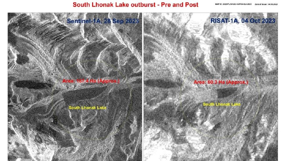
According to the satellite-based study conducted by ISRO's National Remote Sensing Centre (NRSC), the Outburst of the South Lhonak Lake, Sikkim, has been meticulously examined through temporal satellite images taken before and after the calamity.
The maps reveal:
- The state of South Lhonak Lake and its environs, as observed by RISAT 1A on October 4, 2023, at 0600 hrs.
- A side-by-side comparison of South Lhonak Lake before and after the flash flood, as observed by RISAT 1A on October 4, 2023, at 0600 hrs and Sentinel 1A on September 28, 2023, at 1800 hrs.
- Temporal changes in the lake's area on September 17, 2023, September 28, 2023, and October 4, 2023.
The analysis indicates that the lake experienced a rupture, with approximately 105 hectares of water drained out between September 28, 2023, and October 4, 2023. This sudden release of water is believed to have triggered the flash floods downstream.
ISRO has pledged to continue monitoring the situation using satellite data, providing crucial information for disaster management efforts.
Nearly 65 percent of Sikkim's Lhonak Lake, equivalent to around 105 hectares, was emptied after a cloudburst caused the water body to overflow, resulting in flash floods in the Teesta River. The before-and-after satellite images released by ISRO on Wednesday evening vividly depict the lake's dramatic transformation. Photos taken on September 17 and September 28 indicated that the lake held 162.7 and 167.4 hectares of water, respectively.
However, an image captured at 6 AM on Wednesday morning, following the cloudburst and flash floods that devastated the state, displayed a significantly reduced lake with an estimated 60.3 hectares of water remaining.
The revelation that the flash floods were triggered by the bursting of the Lhonak Lake highlights the need for proactive measures to manage and mitigate the impact of glacial lake outburst floods in the Himalayan region.
The disaster has left 23 soldiers among the missing following which a joint rescue operation by the Army and local officials. So far, one army personnel has been successfully rescued, but the search for the others continues.
The region experienced heavy rainfall overnight, with the northern part of the state, where the lake is situated, receiving nearly 50 mm of rain on Sunday, 48 percent more than the norm. Other areas of the state witnessed even more significant rainfall, with eastern regions experiencing a staggering 315 percent unseasonal rainfall, and South Sikkim receiving an astonishing 943 percent more rain than usual.
The cloudburst over Lhonak Lake not only led to its overflow but also raised water levels in the Teesta River, which flows through Sikkim and Bengal before entering Bangladesh. The swollen Teesta further damaged a dam at Chungthang, the state's largest hydropower project, causing a sudden surge of water downstream.
Visuals from North Sikkim's Mangan district displayed catastrophic floods, while a steel bridge at Singtam, just 30 km from Gangtok, was completely washed away. Sections of National Highway 10 were also submerged, making access to several districts extremely difficult.
Copyright©2024 Living Media India Limited. For reprint rights: Syndications Today